Tocllaraju + Ishinca + Urus + Huarapasca
Overview
-
14 days
Duration
-
Jun - Aug
Season
-
Peru
Destination
-
4/6
Strength
-
D+
Difficulty
-
$ 6,300 USD
Per person
Lakes to visit on this expedition:
Lake Radian 12,792ft / 3899m.
Lake Ahuac 14,928ft / 4550m.
Lake Milluacocha 15,092ft / 4600m.
Lake Pacliash 15,190ft / 4630m.
Lake Toclla 15,256ft / 4650m.
Lake Ishinca 16,240ft / 4950m.
Summits attempts on this expedition:
Huarapasca 17,757ft / 5420m.
Ishinca 18,143ft / 5530m.
Urus 17,782ft / 5420m.
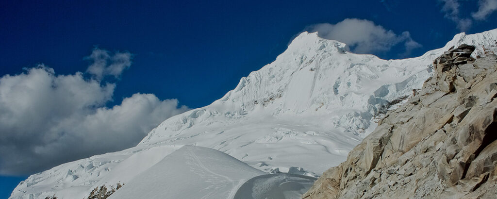
Tocllaraju 19,797ft / 6034m.
Huarapasca presents an excellent addition to the acclimatization stage. With slopes of up to 60°, it will serve not only to adapt our bodies to the altitude but will also allow us to warm up in the climbing technique that the following challenges will demand of us.
Ishinca is one of the most visited mountains. In direct competition with Urus and Pisco, as the best viewpoint of the Cordillera Blanca, it is one of the super classics. The proximity and location of the Vivaque Longoni also generates great ease.
Urus is also another super classic and one of the most climbed mountains to acclimatize before going to larger mountains. At its summit we have one of the best views of the Cordillera Blanca. It is also convenient that our attempt begins and ends at the Ishinca Refuge.
Tocllaraju is the perfect closing of this valley, which has become one of the favorites of mountain lovers, is also one of the most accessible six-thousanders (over 20,000 feet) in the Cordillera Blanca and is the perfect ending to this circuit of classic mountains.
Itinerary
-
Day 1
Arriving in Lima between noon and midnight. Transport to hotel and rest until the next day.
-
Day 2
Trip to Huaraz (10,000ft / 3050m). Beginning of acclimatization. Transport to hotel and rest until the next day.
-
Day 3
Hike to Lake Radian (12,792ft / 3899m). Continuing with acclimatization process.
-
Day 4
Hike to Lake Ahuac (14,928ft / 4550m). A thorough acclimatization is the key to success.
-
Day 5
Huarapasca summit attempt (17,757ft / 5420m). Technical climbing warm up.
-
Day 6
Trekking to Ishinca Refuge (14,272ft / 4350m).
We will have the opportunity to see Lake Milluacocha (15,092ft / 4600m), Lake Pacliash (15,190ft / 4630m) and Lake Toclla (15,256ft / 4650m). -
Day 7
Trekking to Vivaque Longoni (16,404ft / 5000m).
We will have the opportunity to see Ishinca (16,240ft / 4950m). -
Day 8
Ishinca summit attempt (18,143ft / 5530m) and trekking back to Ishinca Refuge (14,272ft / 4350m).
-
Day 9
Urus summit attempt (17,782ft / 5420m).
-
Day 10
Rest / Contingency day.
-
Day 11
Trekking to Tocllaraju high camp (16,404ft / 5000m).
-
Day 12
Tocllaraju summit attempt (19,797ft / 6034m) and trekking back to Ishinca Refugee (14,272ft / 4350m).
-
Day 13
Trekking back to Huaraz (10,000ft / 3050m). Trip back to Lima in the evening.
-
Day 14
Lima.
Dates & Entry
- All dates are all ready confirmed!
-
From Sunday June 15 to Saturday June 28 - 2025.
From Sunday June 29 to Saturday July 12 - 2025.
From Sunday July 13 to Saturday July 26 - 2025.
From Sunday July 27 to Saturday August 9 - 2025.
From Sunday August 10 to Saturday August 23 - 2025. -
Enrollment process:
It is mandatory to have trip cancellation insurance, rescue insurance and medical insurance that covers these types of activities.
Complete the application forms and press the submit buttons: -
Application forms page.
-
After approving your application, we will ask you for the registration fee deposit (this will go towards your trip).
Details
-
GUIDE RATIO:
Hike Lake Radian 1:6 (One guide for every six participants).
Hike Lake Ahuac 1:6 (One guide for every six participants).
Huarapasca summit attempt 1:2 (One guide for every two participants).
Ishinca summit attempt 1:3 (One guide for every three participants).
Urus summit attempt 1:3 (One guide for every three participants).
Tocllaraju summit attempt 1:2 (One guide for every two participants).
-
INCLUDED:
-
A pre-tour meeting scheduled to discuss consultation, questions and specific details via WhatsApp, GoolgeMeet, Zoom or Skype.
-
Tips for buying plane tickets to the tour's starting point.
-
Guidance on the essential personal technical clothing and equipment.
-
Reception at the starting point of the tour.
-
Welcome dinner.
-
All in-country transport during program, including airport shuttles & private or public transport to all itinerary destinations.
-
Meals, according to the needs and/or nutritional tastes of the clients as indicated in the schedule.
-
Technical equipment (Tent for two people, sleeping pad, crampons, ice axes, headlamp, helmet, harness and rope).
-
All group climbing equipment including ropes, snow/ice protection, and miscellaneous hard/soft ware.
-
Nights hostel, double occupancy, and/or group lodging in mountain huts, shelters or refuges required for the tour as indicated in the itinerary.
-
Bilingual professional Mountain Guide (English-Spanish).
-
Bilingual professional Trekking Guide (English-Spanish).
-
Professional expedition cooks.
-
Porters, donkeys, mules and/or horses required for the tour as indicated in the itinerary.
-
All cooking and eating materials.
-
Information about the areas to visit.
-
Technical instruction during the expedition.
-
Printed summit achievement certificate.
-
Daily monitoring of vital signs (morning and evening) of staff and client: oxygen saturation, resting heart rate, blood pressure and temperature.
-
High altitude First Aid Kit.
-
Satellite telephone or InReach for emergency use.
-
National park entry & all community/camping fees.
-
Celebration banquet lunch at the end of trip.
-
NOT INCLUDED:
-
International airfare.
-
Excess baggage charges.
-
Entry visa and airport fees.
-
Sleeping bag (at least -18ºC/0ºF Confort).
-
Technical clothing and mountaineering boots.
-
Fines for breach of park or country rules.
-
Fees for early departure from program.
-
Wire transfer fees.
-
Personal expenses (phone calls, laundry, room service, extra hotel nights, extra meals, etc.).
-
In-town meals.
-
Guide/Staff gratuities.
Glossary
Difficulty
UIAA global difficulties grade system as a whole are more or less the description and classification of the environment in which the route you want to climb is located. They are necessary when the environment presents some characteristics for which it is not sufficient to give only an assessment of the technical difficulties but it must take into
account the factors related to:
• length of the route.
• type of gear placement.
• possibility of retreat.
• isolation.
• approach and descent.
• objective dangers.
• route finding and other factors that weigh heavily on the success of ascent.
This concept is mainly related to the letters F, PD, AD, D, TD, ED, EX (see table below). Adding a “+” or a “-” sign can be used to better adjust the degree. For example, an AD- route will be slightly harder than a PD+.
| Grade | Description |
|---|---|
|
F |
Facile (Easy). Slopes (rock, snow and/or ice), provided below 30 degrees moderate slopes, which amounted progress (in snow sometimes ax). Climbs easy. Some sections in crevassed glacier. Experienced mountaineers can climb without rope. |
|
PD |
Peu Difficile (Bit Difficult). Outstanding (rock, snow and/or ice) with steep slopes always higher than 30 degrees, although walking up. Edges and narrow ridges and air. Climbs of difficulty. Glaciers cracked. Use of the rope may be necessary in more than one occasion. |
|
AD |
Assez Difficile (Difficult). Long earrings (rock, snow and/or ice) with steep slopes always superior to 30 degrees, although they can walk up. Edges and narrow ridges and air. Even moderately difficult climbs vertical terrain. Very complicated cracked and glaciers. Mandatory use of rope. |
|
D |
Difficile (Hard). Climbing maintained both in rock, ice or snow. Only for experienced mountaineers. |
|
TD |
Très Difficile (Very Difficult). Complicated technical climbs and climbs on any terrain with classic climbing. Considerable length, vertical or overhanging slopes, very high exposure, many in remote locations and required technique. |
|
ED |
Extrêmement Difficile (Extremely Difficult). Huge exposure, long-term and in remote locations. |
|
EX |
Exceptionnellement Difficile (Exceptionally Difficult). Simply harder than ED. |
Strength
This grading system is based on the physical effort of the ascent according to distance traveled for the approach, ascent and descent altitude.
| Grade | Description |
|---|---|
|
1/6 |
Ascended altitude from 0 to 1,600ft/500m or tours/treks with a daily distance up to 3mi/5Km. |
|
2/6 |
Ascended altitude from 1,600ft/500m to 3,300ft/1000m or tours/treks with a daily distance up to 6mi/10Km. |
|
3/6 |
Ascended altitude from 3,300ft/1000m to 4,900ft/1500m or tours/treks with a daily distance up to 9mi/15Km. |
|
4/6 |
Ascended altitude from 4,900ft/1500m to 6,500ft/2000m or tours/treks with a daily distance up to 12mi/20Km. |
|
5/6 |
Ascended altitude from 6,500ft/2000m to 8,200ft/2500m or tours/treks with a daily distance up to 15mi/25Km. |
|
6/6 |
Ascended altitude over 8,200ft/2500m or tours/treks with a daily distance over 15mi/25Km. |
Attempts
Every summit will be attempted considering the safety of the clients a first priority. During an ascent we will consider the necessary time to summit within safety margins, weather conditions, objective risk (i.e rock fall, avalanches, etc.), to minimize the risk of the clients or their property. We will also consider cancel a summit attempt based on clients request.
Rest days
These are scheduled days to relax and recover after hard days . It is time for meditation, contemplation and enjoying the landscape. If they are scheduled while in a hotel/hostal is ideal to take advantage of resting in bed, take long showers or any other activity that allows time to energize.